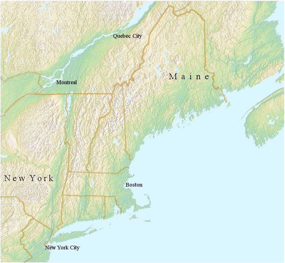
New England Significant Earthquake Atlas
1940
Magnitude 5.5
Dec. 20, 1940, 2:27 a.m. local time
Dec. 24 8:43 a.m. local time
The first earthquake on December 20 and one of about the same intensity on
December 24 are described together. Their epicenters lie in the same general
region west of Whittier, New Hampshire. Although the second shock was of less
duration, it was somewhat more intense than the first. However, the first
shock undoubtedly weakened structures, which resulted in more severe damage
from the second earthquake.
The town of Tamworth, on the edge of the Ossipee Mountains
in central Carroll County, sustained the most damage. Old houses
and chimneys in need of repair were most commonly damaged. Some chimneys
were thrown down, and 20 others were damaged. Also, reports indicate
that well water remained muddy for several days and that many cracks
formed in the crusty snow. Other minor damage included cracked walls,
broken water pipes, fallen plaster, and broken furniture.
At the Riverside Cemetery at Whittier, about 3 kilometers south of
Tamworth, five monuments were displaced. In the nearby towns of West
Ossipee and Chocorua, many old chimneys in need of repair were damaged,
and water in wells became muddy. At Wonalancet, 8 kilometers northwest
of Tamworth, the foundation of an old house (constructed of heavy timber)
was damaged when it shifted about 30 centimeters. Heavy furniture,
including a kitchen stove, moved several centimeters across the floor.
Minor damage occurred at several towns in Maine, Massachusetts, New York,
and Vermont. Reports of the shock also were received from Connecticut,
New Jersey, Pennsylvania, and Rhode Island, as well as from Montreal and
Quebec, Canada. Several small aftershocks occurred over the next several months.
1638
Magnitude 6.5
June 11, 1638, 2:00 p.m.
Central New Hampshire: The location and damage
levels are very uncertain because settlements
were sparse and reports were few. Shaking
was felt strongly along the St. Lawrence River
in Canada and in Boston, widely but less strongly
across southern New England, and on ships
near the coast. Aftershocks were felt for
20 days in eastern Massachusetts.
1727
Magnitude 5.6 (Intensity VII)
Nov. 10, 1727, 10:40 p.m. local time
At Newbury, many stone walls and chimney bricks were shaken down,
and almost all tops of chimneys were knocked off. Considerable changes
occurred in the flow of water in springs and, in some springs, changes
occurred in the character of the water. "Some firm land became quagmire,
and marshes were dried up." The rise and fall of the ground made it
difficult to walk, and houses shook and rocked as if they would fall
apart. Sand blows were reported near Spring Island. Felt from the Kennebec
River in Maine to the Delaware River on the New York-Pennsylvania border
and from ships at sea to the "extreme western settlements." Aftershocks
occurred in the area for several months. The strongest aftershock
(MM intensity V) occurred in the Newbury area on Dec. 28, 1727, and Jan.
4 and Feb. 10, 1728 (local dates).
1755
Magnitude 6.2
Nov. 18, 1755, 4:12 a.m. local time
Cape Ann, Massachusetts: At Boston, about 55
km (34 mi) southwest of Cape Ann, effects were
strongest on infilled land near the wharves.
About 100 chimneys were thrown down, and as
many as 1,500 others were damaged. Walls of
several brick buildings fell. Stone fences fell
throughout the countryside. Springs formed or
stopped. In eastern Massachusetts, ground
cracks opened; some emitted sand and water.
Aftershocks were reported. Shaking was felt
from Nova Scotia to Maryland, and from New
York State to a ship 320 km (200mi) at sea.
Those aboard the ship thought it had run aground.
1869
1904
1869
information on the 1869 earthquake information on the 1869 earthquake information on the 1869 earthquake information on the 1869 earthquake
information on the 1869 earthquake information on the 1869 earthquake information on the 1869 earthquake information on the 1869 earthquake
Magnitude 5.9
Mar. 21, 1904, 1:04 a.m. local time
Easternmost Maine: Chimneys fell, in an
near, two towns in Maine and one in New
Brunswick. Shaking was felt throughout
most of New England, Nova Scotia, New
Brunswick, Prince Edward Island, and
southeastern Quebec. One foreshock was
reported and more than 14 aftershocks
were reported over the next two and a half days.
1884
Magnitude 5.2
Aug. 10, 1884, 2:07 p.m. local time
New York City: Chimneys and bricks fell
and walls and plaster cracked in
Connecticut, northern New Jersey, southern
New York, and eastern Pennsylvania.
The earthquake was felt from southern
Maine to central Virginia, and westward
to northeastern Ohio. Three strong
shocks occurred; the second was the
strongest. Slight aftershocks occurred on
Aug. 11.
1983
Magnitude 5.3
Oct. 7, 1983, 05:18 a.m. local time
At Blue Mountain Lake, one old chimney collapsed, about 20 tombstones slid
or rotated, and some minor cracks formed in plaster walls. Several
landslides were reported. Light damage also occurred at several other
towns in the area, but the most common effects were cracked chimneys,
broken dishes or glassware, and overturned or fallen objects. Although
this earthquake caused only minor damage, it was felt over a wide region,
including two Provinces in Canada and 12 States.
2002
Magnitude 5.1
Apr. 20, 2002, 10:50 a.m.
Some roads, bridges, chimneys and water lines damaged in Clinton and Essex
Counties. Many buildings in the area had cracked walls and foundations, broken
windows and small items knocked from shelves. Maximum intensity (VII) at Au
Sable Forks. Felt from New Brunswick and Maine to Ohio and Michigan and from
Ontario and Quebec to Maryland.
1944
Largest Earthquake in New York
Magnitude 5.8
Sep. 4, 1944, 11:38 p.m. local time
This severe earthquake was felt from Canada south to Maryland and from Maine
west to Indiana. It caused property damage estimated at $2 million at Massena
and Cornwall. Many chimneys in that area required rebuilding, and several
structures were unsafe for occupancy until repaired. Residents of St. Lawrence
County reported that many water wells went dry.
At Massena, in northern St. Lawrence County, 90 percent of the chimneys
were destroyed or damaged and house foundations, plumbing, and masonry
were damaged severely. Similar effects were reported at Cornwall. Cracks
formed in the ground at Hogansburg, and brick-masonry and concrete structures
were damaged. Chimneys were downed in several towns in New York, including
Fort Covington, Keeseville, Malone, Norfolk, Ogdensburg, and Waddington.
2010
Magnitude 5.0
Jun. 23, 2010, 5:41 p.m.
info about the 2010 earthquake
1988
Magnitude 5.9
Nov. 25, 1988
On Friday November 25, 1988 the largest earthquake in eastern North America
in 53 years occurred 35 km south of Chicoutimi, Québec and 75 km north of the
Charlevoix-Kamouraska earthquake zone. This earthquake, referred to as the
Saguenay earthquake, was located in a relatively aseismic region, had a
calculated magnitude of 5.9 mb, 6.5 MN, and a depth of 29 km. It was
characterized by a single foreshock, relatively minor aftershock activity,
and a large amount of high frequency energy.
< Roll mouse over circles for earthquake information >